This section of the site is all about the ME Postcode area, also known as the Medway Postal Area. Explore links to the next level to learn more about specific postcode districts such as ME1.
The ME postcode area represents a group of postal districts in the Medway area of the United Kingdom. The area code ME stands for the letters m and e in MEdway. ME has a population of 607,143 and covers an area of 981,826 hectares. Fun fact: 0.93% of the population of Great Britain lives in this area.
The postcode area falls within the following counties: Kent (100.00%).
Post Towns and Postcode Districts for the ME Postcode
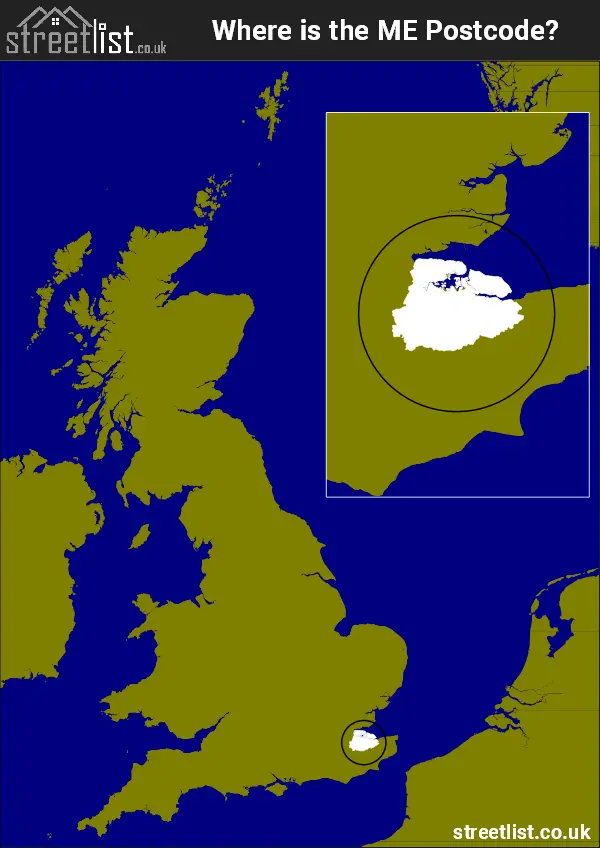
Where is the ME Postcode Area?
The ME Medway Postcode is in the South East of England. The postal area borders the following neighbouring postal areas: DA - Dartford, CT - Canterbury, SS - Southend-on-Sea, RM - Romford and TN - Tonbridge, It also borders The Thames Estuary and The Tidal Thames.
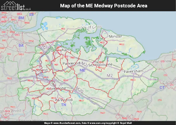
Map of the ME Medway Postcode Area
Explore the ME Medway postcode area by using our interactive map.
Postcode Districts within the ME Medway Postcode Area
There are 20 postcode districts within the Medway postcode area
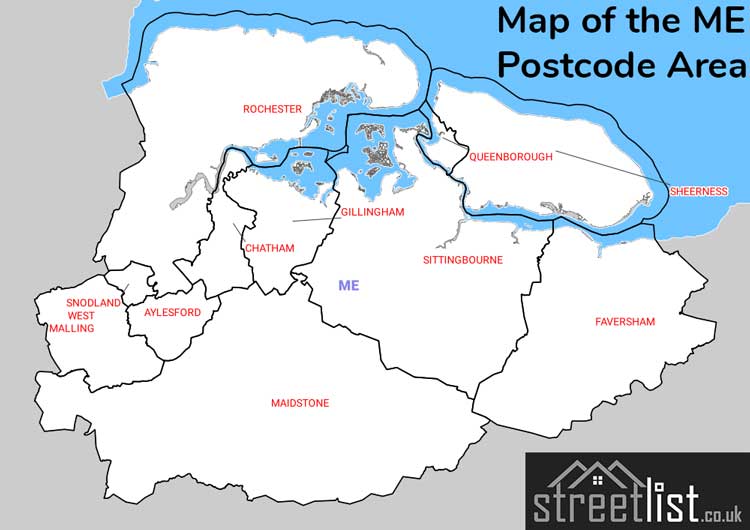
A map showing the boundary of in relation to other areas
There are 11 towns within the Medway postcode area.
| Unit | Area² |
|---|---|
| Hectares | 981,826² |
| Miles | 3,791² |
| Feet | 105,682,768,814² |
| Kilometres | 9,818² |
Postal Delivery Offices serving the ME Medway Postcode Area
- Boughton Monchelsea Scale Payment Delivery Office
- Chatham Delivery Office
- Eastchurch Scale Payment Delivery Office
- Faversham Delivery Office
- Gillingham (me) Delivery Office
- Hoo Scale Payment Delivery Office
- Lenham Scale Payment Delivery Office
- Leys Delivery Office Wn-on-sea Scale Payment Delivery Office
- Lowerstoke Scale Payment Delivery Office
- Maidstone Delivery Office
- Medway Valley Delivery Office
- Rainham (me) Delivery Office
- Rochester Delivery Office
- Sheerness Delivery Office
- Sittingbourne Delivery Office
- Sutton Valence Scale Payment Delivery Office
- Wateringbury Scale Payment Delivery Office
- Yalding Scale Payment Delivery Office
Councils with Postcodes in ME
Towns and Villages within the ME Medway Postcode Area
- Addington - village
- Allhallows - village
- Allhallows-on-Sea - village
- Aylesford - village
- Bay View - village
- Bearsted - village
- Benover - village
- Birling - village
- Blue Bell Hill - village
- Bobbing - village
- Borden - village
- Boughton Monchelsea - village
- Boughton under Blean - village
- Boxley - village
- Bredgar - village
- Bredhurst - village
- Burham - village
- Chart Sutton - village
- Chartway Street - village
- Chatham - town
- Chattenden - village
- Chestnut Street - village
- Cliffe - village
- Cliffe Woods - village
- Conyer - village
- Cooling - village
- Coxheath - village
- Culmers - village
- Cuxton - village
- Danaway - village
- Dargate - village
- Dean Street - village
- Detling - village
- Ditton - village
- Doddington - village
- Dunkirk - village
- East Farleigh - village
- East Malling - village
- Eastchurch - village
- Eastling - village
- Eccles - village
- Eyhorne Street - village
- Farleigh Green - village
- Faversham - town
- Fenn Street - village
- Forstal - village
- Gillingham - town
- Grafty Green - village
- Grain - village
- Graveney - village
- Halfway Houses - village
- Halling - village
- Harrietsham - village
- Hartlip - village
- Herne Pound - village
- Hernhill - village
- High Halstow - village
- Higham - village
- Highsted - village
- Hogben's Hill - village
- Hollingbourne - village
- Hoo St Werburgh - village
- Hunton - village
- Iwade - village
- Kent Street - village
- Kettle Corner - village
- Keycol - village
- Kings Hill - Settlement
- Kingsnorth - otherSettlement
- Kingswood - village
- Kit's Coty - village
- Laddingford - village
- Langley Heath - village
- Larkfield - village
- Leeds - village
- Lenham - village
- Lenham Heath - village
- Lewson Street - village
- Leybourne - village
- Leysdown-on-Sea - village
- Linton - village
- Lower Halstow - village
- Lower Hartlip - village
- Lower Higham - village
- Lower Rainham - village
- Lower Stoke - village
- Lower Twydall - village
- Lower Upnor - village
- Lunsford - village
- Lynsted - village
- Maidstone - town
- Mereworth - village
- Middle Stoke - village
- Milstead - village
- Minster - town
- Moor Street - village
- Neames Forstal - village
- Nettlestead - village
- Nettlestead Green - village
- New Hythe - village
- Newington - village
- Newnham - village
- North Halling - village
- Oare - village
- Offham - village
- Painter's Forstal - village
- Perrywood - village
- Peters Village - village
- Pizien Well - village
- Platt's Heath - village
- Pratling Street - village
- Queenborough - town
- Rochester - town
- Rodmersham Green - village
- Ryarsh - village
- Sandway - village
- Selling - village
- Sheerness - town
- Sheldwich Lees - village
- Sittingbourne - town
- Snodland - town
- Stalisfield Green - village
- Staplestreet - village
- Stockbury - village
- Stoke - village
- Sutton Valence - village
- Teston - village
- Teynham - village
- Three Tees - village
- Throwley Forstal - village
- Trottiscliffe - village
- Ulcombe - village
- Upchurch - village
- Upper Halling - village
- Upper Upnor - village
- Wallend - Settlement
- Warden - village
- Warmlake - village
- Wateringbury - village
- West Malling - town
- West Peckham - village
- Whitehill - village
- Wormshill - village
- Wouldham - village
- Wrotham Heath - village
- Yalding - village