This section of the site is all about the RG Postcode area, also known as the Reading Postal Area. Explore links to the next level to learn more about specific postcode districts such as RG1.
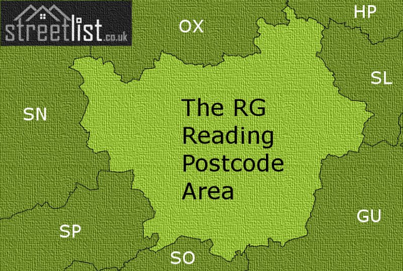
Map of the RG Postcode Area
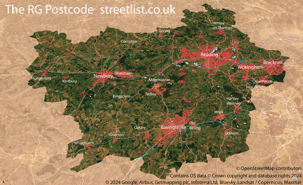

The RG postcode area represents a group of postal districts in the Reading area of the United Kingdom. The area code RG stands for the letters r and g in ReadinG. RG has a population of 778,677 and covers an area of 1,944,376 hectares. Fun fact: 1.20% of the population of Great Britain lives in this area.
The postcode area falls within the following counties: Berkshire (69.99%), Hampshire (22.40%), Oxfordshire (6.91%), Buckinghamshire (0.56%), Wiltshire (0.14%).
Post Towns and Postcode Districts for the RG Postcode
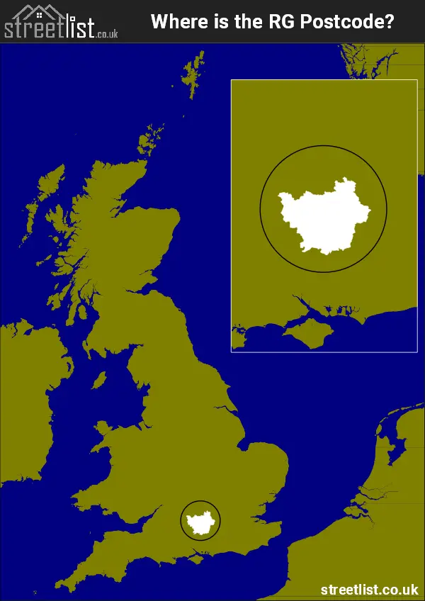
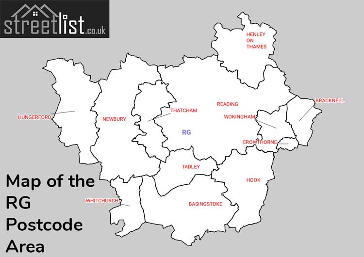
Where is the RG Postcode Area?
The RG Reading Postcode is in the South East of England The postal area borders the following neighbouring postal areas: GU - Guildford, SN - Swindon, SO - Southampton, SP - Salisbury, OX - Oxford, SL - Slough and HP - Hemel Hempstead, and is located inland.
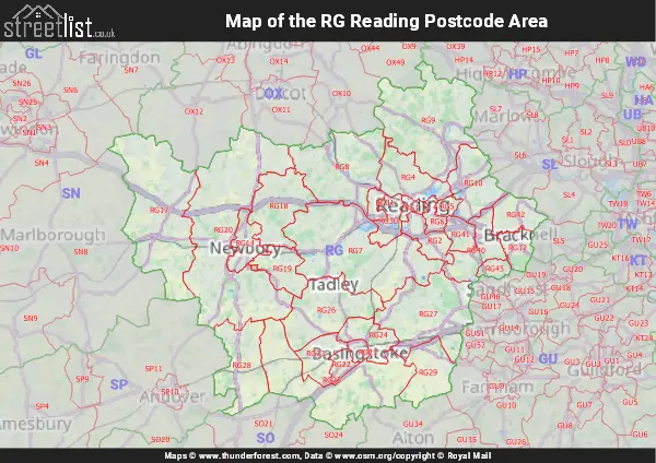
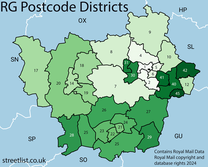
Map of the RG Reading Postcode Area
Explore the RG Reading postcode area by using our interactive map.
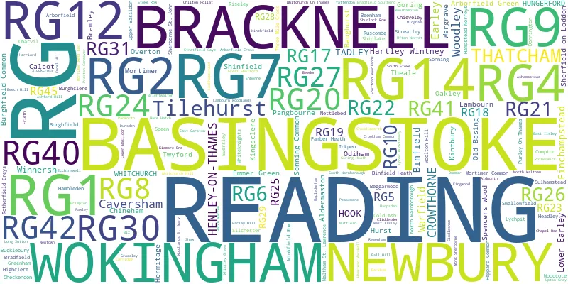
Postcode Districts within the RG Reading Postcode Area
There are 30 postcode districts within the Reading postcode area
A map showing the boundary of in relation to other areas
There are 12 towns within the Reading postcode area.
How the RG Postcode area was numbered
The RG Reading postcode was originally created out of a trio of towns. Reading is the main town and where the first and last letter of the area code comes from. Newbury and Basingstoke were the two significant postal towns that were intended to share the limelight with Reading. Both are well connected to the hub of Reading by road and rail.
Looking at a map of the postcode area today, it looks confusing and difficult to see a logical order. Once you apply the original numbering of districts as seen before 1995, it begins to make sense.
Why is there no RG3 district?
RG3 used to be the district for West Reading and Tilehurst. It was split and renamed RG30 and RG31.
Original Districts
Reading
- Reading
- Whitley, Shinfield and Arborfield Green
- Tilehurst and West Reading (now RG30 and RG31)
- Caversham, Sonning and Sonning Common
- Woodley
- Earley and Lower Earley
- Aldermaston, Mortimer, Silchester, Spencers Wood and Swallowfield
- Goring on Thames, Pangbourne
- Henley on Thames
- Twyford
- Wokingham, Winnersh, Finchampstead, Crowthorne (now RG40, RG41, and RG45)
- Bracknell (Part Split to create RG42)
In addition to Reading, there are post towns of Henley on Thames, Wokingham, Bracknell, and Crowthorne.
Newbury
- Newbury
- Hungerford (now RG17)
- Thatcham (now RG18 and RG19)
- Hermitage and Cold Ash
- Greenham Common and Ashford Hill
- Compton, Woolton Hill, Highclere, Burghclere and Kingsclere
New post towns of Hungerford and Thatcham were created to the east and west of the Newbury area.
Basingstoke
- Basingstoke
- South Ham, Brighton Hill, Hatch Warren, Kempshott and Buckskin
- Oakley, Winklebury and Wootton St Lawrence
- Popley, Chineham, Rooksdown, Sherborne St John, Lychpit and Old Basing
- Overton, North Waltham, Dummer, Preston Candover, Ellisfield, Cliddesden, Upton Grey, Weston Patrick and Mapledurwell
- Tadley, Hannington and Bramley
- Hook, Hartley Wintney, Sherfield on Loddon, Sherfield Park, Mattingley and Rotherwick
- Whitchurch and Hurstbourne Priors
- Odiham, RAF Odiham, North Warnborough, South Warnborough and Long Sutton
The numbering in the Basingstoke Area remains intact however new post towns of Tadley and Hook were formed in areas with expanding populations.
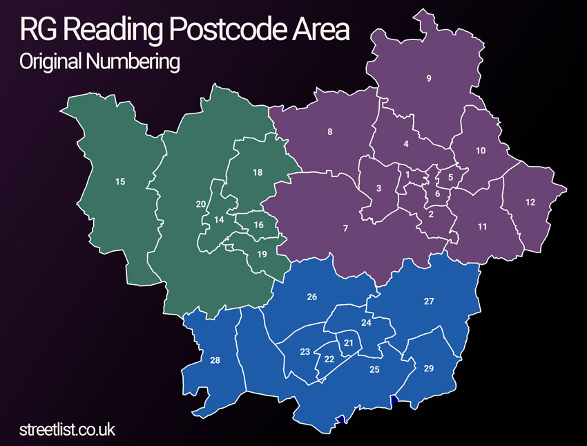
Map of RG Reading Postcode with Original Numbering
| Unit | Area² |
|---|---|
| Hectares | 1,944,376² |
| Miles | 7,507² |
| Feet | 209,290,688,264² |
| Kilometres | 19,444² |
Postal Delivery Offices serving the RG Reading Postcode Area
- Basingstoke Delivery Office
- Bracknell Delivery Office
- Checken Delivery Office N Scale Payment Delivery Office
- Compton Scale Payment Delivery Office
- Crowthorne Delivery Office
- East Reading Delivery Office
- Goring Delivery Office
- Henley On Thames Delivery Office
- Hook Delivery Office
- Hungerford Delivery Office
- Kingsclere Scale Payment Delivery Office
- Lambourn Scale Payment Delivery Office
- Newbury Delivery Office
- Pangbourne Delivery Office
- Reading Delivery Office
- Southend (reading) Scale Payment Delivery Office
- Tadley Delivery Office
- Thatcham Delivery Office
- West Reading Delivery Office
- Whitchurch (rg) Delivery Office
- Wokingham Delivery Office
Councils with Postcodes in RG
Towns and Villages within the RG Reading Postcode Area
- Aldermaston - village
- Aldermaston Soke - village
- Aldermaston Wharf - village
- Arborfield - village
- Arborfield Cross - village
- Arborfield Garrison - village
- Ashampstead - village
- Ashford Hill - village
- Ashmansworth - village
- Ashmore Green - village
- Axford - village
- Ball Hill - village
- Barkham - village
- Basingstoke - town
- Baughurst - village
- Beech Hill - village
- Beedon - village
- Beenham - village
- Binfield - village
- Binfield Heath - village
- Bishop's Green - village
- Bix - village
- Boxford - village
- Bracknell - town
- Bradfield - village
- Bramley - village
- Bramley Green - village
- Brightwalton - village
- Brimpton - village
- Brimpton Common - village
- Brockhill - village
- Bucklebury - village
- Burghclere - village
- Burghclere Common - village
- Burghfield - village
- Burghfield Common - village
- Burnt Hill - village
- Caversham - Urban Area
- Chaddleworth - village
- Chalkhouse Green - village
- Chapel Row - village
- Charter Alley - village
- Charvil - village
- Chazey Heath - village
- Checkendon - village
- Chieveley - village
- Chilton Foliat - village
- Church End - village
- Cliddesden - village
- Cold Ash - village
- Compton - village
- Cray's Pond - village
- Crazies Hill - village
- Crowthorne - town
- Curridge - village
- Dogmersfield - village
- Dummer - village
- East End - village
- East Garston - village
- East Ilsley - village
- Eastbury - village
- Ecchinswell - village
- Eddington - village
- Ellisfield - village
- Elvetham - otherSettlement
- Elvetham Heath - village
- Enborne Row - village
- Englefield - village
- Eversley - village
- Eversley Centre - village
- Eversley Cross - village
- Farley Hill - village
- Fawley - village
- Finchampstead - village
- Fingest - village
- Freefolk - village
- Frieth - village
- Frilsham - village
- Gallowstree Common - village
- Goring - village
- Great Lea Common - village
- Great Shefford - village
- Greenham - village
- Greywell - village
- Hambleden - village
- Hampstead Norreys - village
- Hamstead Marshall - village
- Hannington - village
- Hare Hatch - village
- Harpsden - village
- Hartfordbridge - village
- Hartley Wespall - otherSettlement
- Hartley Wintney - village
- Hazeley - village
- Headley - village
- Heckfield - village
- Henley-on-Thames - town
- Hermitage - village
- Highclere - village
- Highmoor Cross - village
- Hook - village
- Hound Green - village
- Hungerford - town
- Hungerford Green - village
- Hurst - village
- Hurstbourne Priors - village
- Inhurst - village
- Inkpen - village
- Kidmore End - village
- Kiln Green - village
- Kingsclere - village
- Kingwood Common - village
- Kintbury - village
- Knowl Hill - village
- Lambourn - village
- Lambourn Woodlands - village
- Langley Common - village
- Laverstoke - village
- Leckhampstead - village
- Litchfield - village
- Little Frieth - village
- Little Hoddington - village
- Little Hungerford - village
- Little London - village
- Long Sutton - village
- Longlane - village
- Lower Assendon - village
- Lower Basildon - village
- Lower Common - village
- Lower Common - village
- Lower Green - village
- Lower Padworth - village
- Lower Shiplake - village
- Maiden's Green - village
- Mapledurwell - village
- Mattingley - village
- Middle Assendon - village
- Midgham - village
- Mill End - village
- Monk Sherborne - village
- Mortimer - village
- Mortimer West End - village
- Nately Scures - village
- Nettlebed - village
- New Town - village
- Newbury - town
- Newell Green - village
- Newnham - village
- Newtown - village
- Newtown Common - village
- North Waltham - village
- North Warnborough - village
- Northend - village
- Nuffield - village
- Oakley - village
- Odiham - village
- Old Basing - village
- Old Burghclere - otherSettlement
- Old Warren - village
- Overton - village
- Padworth Common - village
- Pamber End - village
- Pamber Green - village
- Pangbourne - village
- Peasemore - village
- Penwood - village
- Peppard Hill - village
- Pheasant's Hill - village
- Phoenix Green - village
- Preston Candover - village
- RAF Odiham - Settlement
- Ramsdell - village
- Reading - town
- Remenham Hill - village
- Riseley - village
- Rotherfield Greys - village
- Rotherfield Peppard - village
- Rotherwick - village
- Ruscombe - village
- Russell's Water - village
- Ryeish Green - village
- Shalbourne - village
- Shefford Woodlands - village
- Sherborne St John - village
- Sherfield on Loddon - village
- Shinfield - village
- Shiplake - village
- Shurlock Row - village
- Silchester - village
- Sindlesham - village
- Skirmett - village
- Sonning - village
- Sonning Common - village
- South Stoke - village
- South Warnborough - village
- Southend - village
- Southend - otherSettlement
- Southrope - village
- Spencers Wood - village
- Stanford Dingley - village
- Steventon - village
- Stockcross - village
- Stoke Row - village
- Stonor - village
- Stratfield Mortimer - village
- Stratfield Saye - village
- Streatley - village
- Sulham - village
- Sulhamstead - village
- Swallowfield - village
- Tadley - town
- Thatcham - town
- The Holt - village
- Theale - village
- Three Mile Cross - village
- Tidmarsh - village
- Tokers Green - village
- Turville - village
- Turville Heath - otherSettlement
- Tutts Clump - village
- Twyford - village
- Ufton Nervet - village
- Up Nately - village
- Upper Basildon - village
- Upper Bucklebury - village
- Upper Lambourn - village
- Upper Woolhampton - village
- Upton Grey - village
- Waltham St Lawrence - village
- Wargrave - village
- Warren Row - village
- Wash Water - village
- West End - village
- West Heath - village
- West Ilsley - village
- Whistley Green - village
- Whitchurch - town
- Whitchurch Hill - village
- Whitchurch-on-Thames - village
- Wickham - village
- Wildmoor - otherSettlement
- Winchfield - village
- Winchfield Hurst - village
- Winkfield Row - village
- Winnersh - Urban Area
- Winterbourne - village
- Wokingham - town
- Woodcote - village
- Woodlands St Mary - village
- Woodley - town
- Woolhampton - village
- Woolton Hill - village
- Wootton St Lawrence - village
- World's End - village
- Yattendon - village