This section of the site is all about the L Postcode area, also known as the Liverpool Postal Area. Explore links to the next level to learn more about specific postcode districts such as L1.
Map of the L Postcode for Livepool

Quick Facts about the L Postcode
| Width from East to West | 15.48 mi |
| Height from North to South | 23.35 mi |
| Area of L | 200.25 mi² |
| Maximum Width | 23.62 mi |
| Perimeter of Postcode Area | 89.76 mi |
| Number of Postcode Districts | 49 |
| Number of Postcode Sectors | 415 |
| Number of Post Towns | 4 |
| Number of Postcodes | 20,538 |
The L postcode area represents a group of postal districts in the Liverpool area of the United Kingdom. The area code L stands for the letters l in Liverpool. L has a population of 857,079 and covers an area of 513,986 hectares. Fun fact: 1.32% of the population of Great Britain lives in this area.
The postcode area falls within the following counties: Merseyside (93.38%), Lancashire (6.39%), Cheshire (0.23%).
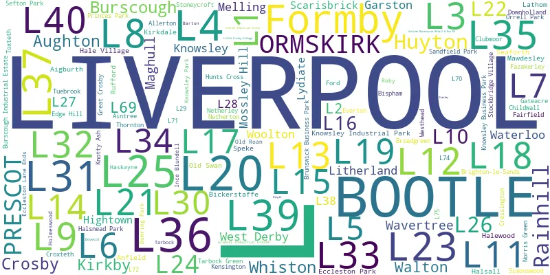
Post Towns and Postcode Districts for the L Postcode
- L1 Merseyside
- L2 Merseyside
- L3 Merseyside
- L4 Merseyside
- L5 Merseyside
- L6 Merseyside
- L7 Merseyside
- L8 Merseyside
- L9 Merseyside
- L10 Merseyside
- L11 Merseyside
- L12 Merseyside
- L13 Merseyside
- L14 Merseyside
- L15 Merseyside
- L16 Merseyside
- L17 Merseyside
- L18 Merseyside
- L19 Merseyside
- L20 Merseyside
- L21 Merseyside
- L22 Merseyside
- L23 Merseyside
- L24 Cheshire (11%), Merseyside (88%)
- L25 Merseyside
- L26 Merseyside
- L27 Merseyside
- L28 Merseyside
- L29 Merseyside
- L31 Lancashire (1%), Merseyside (98%)
- L32 Merseyside
- L33 Lancashire (2%), Merseyside (97%)
- L36 Merseyside
- L37 Lancashire (1%), Merseyside (98%)
- L38 Merseyside
- L67
- L68
- L69 Merseyside
- L70
- L71
- L72
- L74
- L75
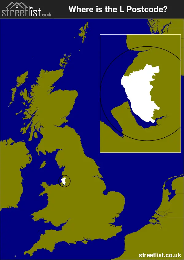
Where is the L Postcode Area?
The Liverpool L Postcode is in the North West of England. TheL postal area borders the following neighbouring postal areas: PR - Preston, WN - Wigan, CH - Chester and WA - Warrington, It also borders The Irish Sea and The Mersey.
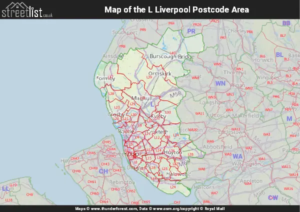
Map of the L Liverpool Postcode Area
Explore the L Liverpool postcode area by using our interactive map.
How built up is the L Postcode?
I've calculated the total area covered by building footprints within the L postcode area.
By analyzing this against the total area, I've determined the percentage of the area that's developed, this will give you an idea of how urban or rural the L postcode region is.
The higher the percentage the more urban the area is. For example the least urban district is L29 and the most urban is L2.
| Postcode District | Total Area (m²) | Footprint Area (m²) | Built Percentage % |
|---|---|---|---|
| L29 | 7,769,063 | 38,423 | 0.49% |
| L38 | 11,981,076 | 191,132 | 1.60% |
| L40 | 91,238,123 | 1,670,754 | 1.83% |
| L39 | 82,307,530 | 1,730,592 | 2.10% |
| L37 | 35,786,827 | 1,418,962 | 3.97% |
| L31 | 30,481,098 | 1,466,253 | 4.81% |
| L34 | 19,919,823 | 1,013,774 | 5.09% |
| L35 | 21,422,368 | 1,246,656 | 5.82% |
| L27 | 2,810,777 | 195,940 | 6.97% |
| L26 | 7,662,402 | 542,273 | 7.08% |
| L33 | 19,712,806 | 1,707,435 | 8.66% |
| L23 | 13,446,786 | 1,263,571 | 9.40% |
| L28 | 1,713,824 | 178,651 | 10.42% |
| L12 | 10,288,925 | 1,164,229 | 11.32% |
| L24 | 18,038,445 | 2,069,302 | 11.47% |
| L32 | 6,364,518 | 767,198 | 12.05% |
| L10 | 5,472,096 | 705,151 | 12.89% |
| L17 | 5,878,169 | 770,093 | 13.10% |
| L25 | 10,051,848 | 1,373,183 | 13.66% |
| L21 | 6,811,258 | 958,469 | 14.07% |
| L16 | 3,878,418 | 557,751 | 14.38% |
| L36 | 11,004,710 | 1,645,772 | 14.96% |
| L30 | 6,326,213 | 948,590 | 14.99% |
| L19 | 6,796,006 | 1,056,530 | 15.55% |
| L18 | 6,697,779 | 1,053,330 | 15.73% |
| L22 | 2,969,643 | 486,321 | 16.38% |
| L11 | 6,181,029 | 1,015,330 | 16.43% |
| L14 | 4,936,946 | 908,162 | 18.40% |
| L9 | 8,500,587 | 1,603,580 | 18.86% |
| L5 | 3,419,666 | 647,326 | 18.93% |
| L20 | 9,397,129 | 1,865,337 | 19.85% |
| L4 | 6,334,203 | 1,286,337 | 20.31% |
| L6 | 3,645,733 | 768,661 | 21.08% |
| L13 | 5,209,515 | 1,110,884 | 21.32% |
| L15 | 4,312,870 | 965,211 | 22.38% |
| L8 | 4,521,877 | 1,022,571 | 22.61% |
| L3 | 5,152,105 | 1,172,135 | 22.75% |
| L7 | 3,435,874 | 872,873 | 25.40% |
| L1 | 1,521,607 | 670,404 | 44.06% |
| L69 | 261,806 | 119,281 | 45.56% |
| L2 | 321,462 | 220,724 | 68.66% |
| L Total | 513,982,940 (m²) | 40,469,151 (m²) | 7.87% |
Postcode Districts within the L Liverpool Postcode Area
There are 41 postcode districts within the Liverpool postcode area
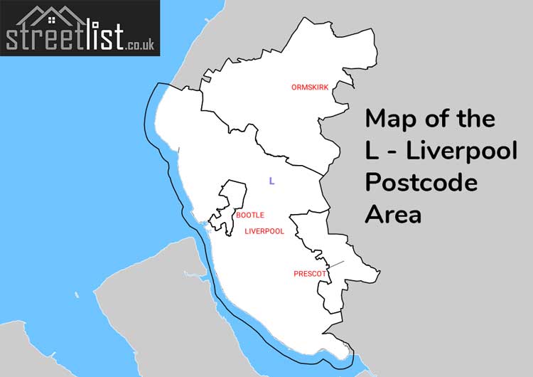
A map showing the boundary of L in relation to other areas
There are 10 towns within the Liverpool postcode area.
| Unit | Area² |
|---|---|
| Hectares | 513,986² |
| Miles | 1,985² |
| Feet | 55,324,939,054² |
| Kilometres | 5,140² |
Postal Delivery Offices serving the L Liverpool Postcode Area
- Bootle Delivery Office
- Crosby Delivery Office
- Formby Delivery Office
- Garston Delivery Office
- Huyton Delivery Office
- Kirkby Delivery Office
- Lark Lane Delivery Office
- Liverpool 1-3
- Liverpool 4-5
- Liverpool 6-7
- Liverpool 8
- Maghull Delivery Office
- Mossley Hill Delivery Office
- Ormskirk Delivery Office
- Prescot Delivery Office
- Seaforth Delivery Office
- South Eastern (l) Delivery Office
- Speke Delivery Office
- Walton (l) Delivery Office
- West Derby Delivery Office
- Woolton Delivery Office